A Hike in 4 Movements – The Great South West Walk

The Great South West Walk is a 250km circuit trail between Portland and Nelson on Victoria’s south west coast. It is described as “Nature’s Very Own Symphony – in 4 Movements” covering four distinct environments – Forest, River, Beach and Capes and Bays. You can walk short loops, day walks, overnights or complete the full circuit in one big hit. No guesses as to which option I took.

The trail is very well marked but carrying a map is always useful. There is also a very good guide book available from the Great South West Walk website. The distances stated on the map and in the book did not always agree and often did not match my watch (and I wasn’t the only one – there were several emphatic alterations made to the information boards in the campsites by exhausted hikers who found themselves walking an extra couple of kilometres they weren’t expecting) so I’ve included all distances. Bear in mind that my watch will include small sidetrips for viewpoints, meal breaks and loo stops.

First Movement – The Forest

Day 1: Portland Visitor Centre to Cubby’s Camp
Book says: 20.2km
Map says: 19.5km
Garmin says: 20.0km
Day 2: Cubby’s Camp to Cut Out Camp
Book says: 15.0km
Map says: 14.5km
Garmin says: 15.0km

Day 3: Cut Out Camp to Fitzroy Camp
Book says: 22.9km
Map says: 19.9km
Garmin says: 25,6km
Day 4: Fitzroy Camp to Moleside Camp
Book says: 21.6km
Map says: 20.3km
Garmin says: 21.7km

I’m going to say straight up that this was not my favourite leg. I like walking in the bush but I discovered I have a tolerance level of about 2 days, especially if the walking is pretty flat. I can do longer if there’s a bit more variety with climbs and hilltop views. It also started with a lot of walking on roads to get out of Portland and a stretch along uncomfortable gravel beside a railway.

It probably didn’t help that it was pretty wet for the first few nights, to the extent that by the time I got to Fitzroy Camp, I set up my tent in the shelter just to have a break from the sound of rain on the fly all night.

And then there was this incident on my second night:

Bloody leeches. Literally.

(Being on the back of my neck, the only way I could see what was happening was to prop my phone up on the Hiker Registration box, set the camera to selfie mode on a 5 second timer, line myself up, press the button and turn around to take a photo of my neck.)

I was also alone the whole time both while walking during the day and in every camp at night. I love my own company and don’t mind solitude but sometimes you can have too much of a good thing. My only company when the sun went down and the night was dark and cold were the possums.

There was one big positive. I chose to do this walk in winter partly because I need to take advantage of every holiday break and this one seemed achievable in winter but mostly because I have a thing for fungi and I was promised fungi on this walk. And I got fungi. Oh boy, did I get fungi.

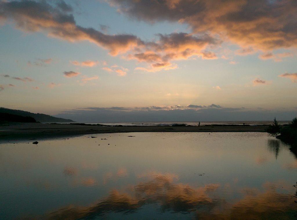
Second Movement: The River

Day 5: Moleside Camp to Patterson’s Camp
Book says: 32.8km
Map says: 30.5km
Garmin says: 33.1km

Day 6: Patterson’s Camp to Nelson
Book says: 20.9km
Map says: 19.8km
Garmin says: 21.6km

I absolutely loved this section and would go back and do it again. So why cover it in only two days? Because when I was suffering in the forest, I decided I wanted to get this foresty, leechy leg over with and get to the coast and thus planned to do a double section, skipping Battersby Camp. By the time I realised how lovely it was along the river, I’d already become rather attached to the idea of two nights in Nelson so I stuck with the plan. It also probably helped that the sun came out. And I met some day hikers, the first people I had spoken to in nearly five days.

You can also canoe along the Glenelg River and the campsites are set up accordingly. I’ve put that on my bucket list.

Part of the trail actually crosses the border into South Australia so for a while you find yourself walking interstate. It’s a little bit weird.

The sign at Battersby Camp actually had information about leeches. Really? You couldn’t have told me this several camps back?? When I stopped here for lunch I did enjoy the company of a cheeky Superb Fairy Wren who wanted to share my wrap.

Intermission: ‘Rest’ Day in Nelson

I stayed at the Kywong Caravan Park in Nelson and I would heartily recommend it to anyone but especially as a break point in a long hike. There are both powered and unpowered sites but also cabins. There is a toilet/shower block that runs on solar hot water so the hot water never runs out and a laundry with both washing machines and dryers. (You can get coins from the office. It cost me $5 to wash and dry all my clothes.) There’s a camp kitchen with stove, barbeques, microwave, kettle, toaster, fridge, sinks, a table and chairs and a tv. It was lovely to sit inside a building to eat my meals. I was able to wash out all my ziplock meal bags and repackage the next week’s food. (I dropped off a resupply box on my way to Portland and the office was more than happy to look after it.)

On my so-called rest day, I decided to take a walk to Livingston’s Island which has a very enjoyable nature walk. Just a little less enjoyable in the pouring rain. (It wasn’t raining when I left. I’m not that stupid or masochistic.) The walk came to 14.6km, perhaps an odd choice on a day I should be resting but I didn’t want my legs to forget why we were there.

The service station serves very good coffee and even better crunchy hot chips. The pub serves good pub grub and has an excellent wine list. I may be speaking from experience.

Third Movement: The Beach

Day 8: Nelson to Monibeong Camp
Book says: 22.6km
Map says: 21.0km
Garmin says: 25.0km

Day 9: Monibeong Camp to Swan Lake Camp
Book says: 17.0km
Map says: 16.8km
Garmin says: 17.2km

Day 10: Swan Lake Camp to Tarragal Camp
Garmin says: 24.4km

Day 11: Tarragal Camp to Springs Camp
Garmin says: 32.7km

The third part of the journey travels along the beach of Discovery Bay. Beach walking can be tough but I did find the sand here easier to manage than on the Great Ocean Walk. Not as soft nor as thick. However…

It is recommended that you walk the GSWW in an anti-clockwise direction. This allows you to finish with the spectacular capes section and also means you have the wind at your back on the beach walks. If you walk in the warmer months. In summer, the winds blow from the north-west and this theory applies. If, however, you are ridiculous like a blogger we all know and decide to walk in winter, the winds blow from the south-east. Straight into your face. Add in the occasional burst of horizontal rain and, well, let’s just say that I was happy to walk the longer 7.5km inland route to Monibeong Camp rather than spend another 5.5km on the beach. It was a nicer walk in any case.

There was lots to look at on the first two legs – weird rock formations, interesting shells and flotsam and jetsam scattered along the beach.

There were also lots of seabirds including the threatened Pied Oyster Catcher and Hooded Plover. It was fun to “peep peep” back at the oyster catchers and reassure the scurrying little plovers that you weren’t out to get them. I understand their trepidation. There were several fox tracks in the sand along the beach.

Now, you may have noticed that I haven’t inserted the book and map distances on Days 10 and 11. This is because from Swan Lake Camp you have two choices. You can walk the approximate 22km inland over Mt Richmond to Tarragal Camp and then continue on to Springs Camp the next day (13km) or you can walk along the beach straight to Springs Camp (23km) and thus skip a day’s walking.

I wanted to do both.

So I walked along the beach but instead of continuing to Springs Camp, I turned off and walked to Tarragal Camp. The next day, I got up early, hiked to the top of Mt Richmond, walked back to camp, packed up and continued on to Springs Camp.

Good Morning from Mt Richmond

My advice, however, would be not to bother with the beach section. Take the inland route over Mt Richmond and stay at Tarragal. It’s worth the extra day. I found this last beach section long and tedious with not much to see. Tarragal and the Mt Richmond route, on the other hand, was Koala Central.

Just bring your ear plugs for overnight if you don’t want to be woken by grunting, growling koalas complaining that you’ve set up your tent in the path of their favourite tree. Although, I was glad to hear them when I detected a juvenile male trying to sound like his elders and instead sounded like someone having an asthma attack. I couldn’t stop laughing. (I wish I had a recording but I turn my phone off at night and I couldn’t be bothered turning it back on.)

If you don’t know what koalas sound like, here’s an example. It’s a good idea to know what this sound is so as not to be terrified you are about to be invaded by a herd of wild pigs in the middle of the night.

You’ll also pass the Bridgewater Lakes and Tarragal Caves which are well worth a visit.

Fourth Movement: Capes and Bays

Day 12: Springs Camp to Mallee Camp
Book says: 32.4km
Map says: 32.0km
Garmin says: 33.5km

Day 13: Mallee Camp to Portland Visitor Centre
Book says: 22.2km
Map says: 22.0km
Garmin says: 24.7km

This was my favourite leg. Absolutely stunning scenery, interesting things to see and the occasional adrenaline rush when the path veered just a little too close to the edge of the cliff. (These sections always seemed to come near the end of a long day when I was tired and more likely to stumble. I did a lot of very slow, very purposeful walking with my eyes glued to my feet on the path at times.)

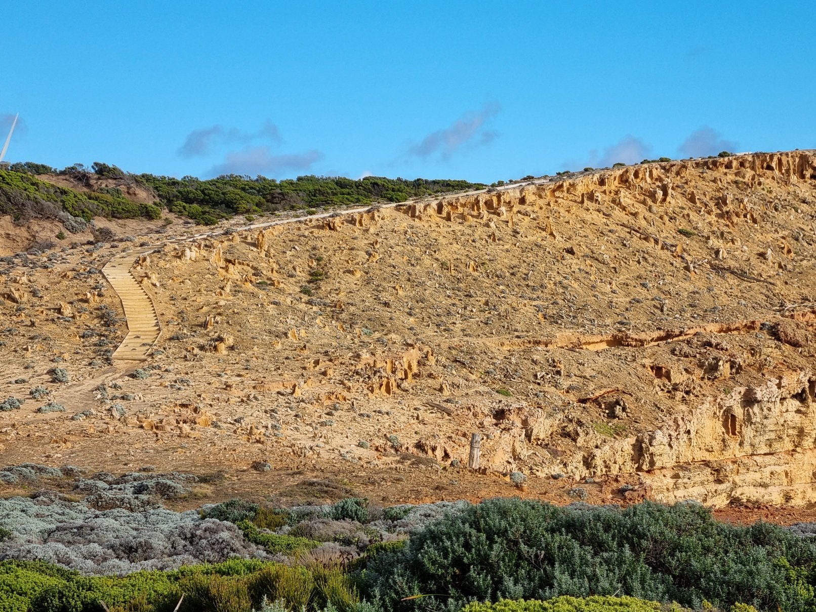
There were so many sights on this leg that I’d like to go back with more time and see them again. A petrified forest (actually limestone tubes eroded by water), freshwater springs on ocean rocks, blowholes, shipwrecks, a seal colony and a walk along some of the highest coastal cliffs in Victoria.

There was also coffee with fresh milk in it. And a scone with jam and cream. It’s the little things. Thank you Cape Bridgewater Café.

If you stay at Trewalla Camp, you should also arrive at Cape Nelson Lighthouse in time for afternoon tea in the café the next day. Since I decided to continue on to Mallee Camp instead, I’d have needed them to be offering Sunset Tea to partake of their delights. (Because I am ridiculous. We’ve already established this fact.)

Cape Nelson Lighthouse

It was at Mallee Camp that I met my first fellow GSWW hiker in camp. It only took 12 days. He was only starting out, going in the opposite direction. (Because he is not ridiculous.) Mallee Camp is the only campsite with tent platforms/sandpits as it is set in an area of indigenous middens and setting up your tent in the designated areas helps protect the fragile environment.

Even on the last day there was still so much to see – an Enchanted Forest, hidden bays, a gannet colony (the only one on the Australian mainland) and a walk beneath enormous wind turbines for an up close appreciation of renewable energy production.

“She’s looking this way. Quick, pretend you’re a windmill!”

The walk into Portland does feel a bit interminable as you wait and wait for a glimpse of the pier but it eventually arrived and I was relieved to spot my car still where I left it.

Then it was only for me to drive the 3.5 hours home fuelled on triple shot espresso and Squirms.

And my GSWW adventure was thus over. It felt simultaneously like I had been away forever and hardly at all.

What I Learned

  • Distances can be deceiving. On my second last day, I took a photo across the ocean and realised to my horror that the tiny speck on the end of the cape in the distance was the lighthouse past which I had to walk that day to get to camp. It looked about three days away. It wasn’t. I got there before dark. I’m still not sure how.
  • I am not good at lighting fires. My former Girl Guide leaders would be horrified.
  • I don’t much like being alone after dark. I came home thinking I would need to revamp my Great North Walk plans to stay in more established accommodation rather than camping alone in the campsites. About three days later I decided “Meh. It will be fine.” Because…
  • Much like childbirth, marathons or any other activity that has you thinking at the time that you will never do this to yourself again, bad days or moments on a long hike tend to fade in the memory leaving only the excitement and enjoyment of being out in nature.

I wish to acknowledge the Gunditjmara people on whose land I journeyed and pay respect to their Elders past, present and emerging.

Great Ocean Walk – I’m Mad But Not Stupid (Mostly)

I just undertook my first solo multi-day hike, part of my new Do The Thing You Think You Cannot Do project. I spent seven days hiking the Great Ocean Walk in Victoria’s Otways National Park.

The recommended itinerary for this hike is eight days. I stuck one ‘double’ day (skipping a campsite) in the middle to keep the length down to a manageable level between Easter and the new school term starting. I was pretty sure I could handle 20+ kilometre days (having done the 100km Oxfam Trailwalker without sleep 3 times – you can read about two of them here and here) but this was my first ‘thru-hike’ and I thought I should give myself some room to manoeuvre, particularly because some of the sections involved beach walking subject to tides.

The verdict? I loved it! This is the beginner thru-hiker’s ideal trail. The distances are manageable, the campsites are fabulous and the signposting is the best I’ve seen.

Are there hard bits? Of course.

There’s beach walking. For anyone from outside Victoria, let me warn you, Victorian sand is brutal. It is soft, it is deep and it doesn’t care how tired you are.

There are hills. Some call them lung-busting. I call them glute-busting because that is the bit of me that hurt the most at the top.

There are stairs. Soooo many stairs in some cases. Pace yourself.

But because, on the full itinerary, the distances are pretty small (between 10-16 kilometres) you have the option to either push hard all morning and then relax in the camp for the afternoon (usually my MO) or to take your time, take plenty of breaks and still be in camp in time for an afternoon cup of tea or coffee (if you bring enough gas – more on that later). I honestly believe you could do this hike as a family with kids if you took your time. Of course, tide times come into it so you may have a hard push at times but there’s not that many compulsory beach walks that require such effort so don’t stress.

So, here’s a quick run down of my journey. Distances are according to the GOW guide, not necessarily what my Garmin watch told me. Times are what was on my watch but should be taken with a grain of salt because I more often than not forgot to turn it off when I got to camp.

Day 1 Apollo Bay to Elliot Ridge Distance 10km Time 2.5 hours

I was happy for this leg to be short because it started with a 2 hour and 15 minute bus ride from my home town. I also took time for a burger, fries and beer lunch at the Apollo Bay Hotel because you need carbs, right?

The weather on this day was not fab and by the time I arrived in camp things were decidedly damp. Each of the GOW campsites have fabulous shelters with benches and tables. Unfortunately, at Elliot Ridge, a mother and daughter had decided to set up camp in the shelter. Yes, including the tent. I can only be grateful that they were attempting to do the hike in, effectively, four and a half days so I never saw them again and they were gone by the time the rest of us in camp needed to pack up our tents in the rain. It’s useful to be able to store your gear in a shelter while you dismantle your tent.

It was at this camp that I met a couple from Melbourne who would be my company through the remainder of the walk (although we had a couple of different campsites in the next few legs due to bookings).

Day 2 Elliot Ridge to Blanket Bay 12km Time: 3.5 hours

I can’t say this was the most interesting leg, the bulk of it being along fire management trails. With the added rain, the only adrenaline was expended trying to pick my way across the muddy sections without getting my feet wet. (I choose to wear non-waterproof shoes – if you want to know why, there’s an explanation at the end of this post.) I did, at one point, fail in this endeavour and incur one damp foot but otherwise the wet didn’t really dampen the enthusiasm. [laughs at own wittiness with words]

A soggy tea break. Yes, I brought a chair. So sue me.

Blanket Bay was one of my favourite campsites. I really like that there are separate GOW campsites in places that also include a ‘normal’ campsite (for car and caravan campers and the like) in the recognition that GOW hikers are unlikely to want to party into the wee hours (well, at least until 10pm when it’s recommended campers consider others) and much more likely to be in bed by 8pm at the absolute latest. I loved it because it was, simply, beautiful. Especially when the moon began to rise over the ocean.

Day 3 Blanket Bay to Cape Otway 11km Time: 3 hours

Had I known (read ‘bothered to research’) that the Cape Otway Lightstation was closed on Wednesdays and Thursdays, I suspect I would have pushed on to Aire River on this day. What do you do with a whole half day when the main attraction is closed? I don’t completely regret it because Cape Otway GOW Camp is rather lovely but it did feel a bit like a wasted day.

Day 4 Cape Otway to Johanna Beach 24km Time: 5.5 hours

This was my long day and I knew that it would end with a long-ish beach walk and a river crossing at Johanna Beach. At this point, I will confess that despite growing up near the Victorian southern coast that coast often scares me to death. So I take high tide times seriously. Unfortunately for me, high tide on Johanna Beach was scheduled for 3pm. With a long hike ahead of me, I felt I had no alternative than to head off at some ungodly hour of the morning to ensure I hit the beach as far away from high tide as possible.

I got up, packed up and was away by 5:40am. I pushed hard. I ate pop tarts for breakfast without stopping. I got to Johanna Beach at 10:25am. Made it to camp at 11.30. The couple I met at Elliot Ridge came many hours later and still managed a calm crossing of Johanna Beach. So maybe the ultra-early start wasn’t totally warranted but on the plus side I got the best camp spot in the best campsite on the walk.

Million dollar views for $17 a night

And I’m not sorry I took the safe route. To be honest, Johanna Beach scared me. The power of the waves was both awesome and fearsome and I was left with no questions as to why this section of the coast is known as the Shipwreck Coast. Would I have loved a dip in the sea to feel clean? You bet. Did I take a dip in the sea? Not on your life (or, more accurately, mine).

A sound of the sea

(Not at Johanna Beach but just to give you an idea. Johanna Beach was much wilder.)

BUT. This was, by far, my favourite leg of the walk. If I had a friend who said to me “I just want to walk one leg, which one should I do?” this is the one I would recommend. It was the one that best showcased the Otways. There were sand dunes, there were cliff tops, there was rainforest, there was beach walking. If you only have time for one section of the Great Ocean Walk, choose this one. Plus, it ends with the most scenic of the GOW-dedicated campsites. So for all you ‘I’m on a limited time budget’ folks, this, THIS, is the leg you should do. IMHO, of course.

Day 5 Johanna Beach to Ryans Den 14km Time: 3.5 hours

If the previous leg was my best, this is my worst. The first 7.5km are basically along road.

I guess, if you’re foreign and kangaroos excite you (rather than being a rather tasty choice in the meat section of the supermarket) you may find it a tad more interesting but seriously, what hiker enjoys walking along a road for many kilometres?

The remainder was basically horrible hills and stairs. Thankfully, the campsite was lovely.

A sunset view from the campsite lookout

A note about GOW campsites: Some of the sites have ‘Group’ sites as you first walk in. These are designed, obviously, for groups. Beyond this, you will find individual numbered sites. There’s a helpful map at the entry to each camp so you can suss out in advance which is the best one to aim for if you’re early enough to have first pick. As an introvert, I loved the little tucked away campsites. If you are of the more sociable type, you could, at least in low season, set up your tent in the group section to join the gang. However, not all campsites cater to groups so at some point you will have to enjoy your own company. Although, in my experience, the bonding that goes on among GOW hikers means you’ll never really ever be on your own.

Having arrived early, as always, it was an enjoyable excursion to follow the Ryans Den Track to visit Ryans Den with a couple of my fellow hikers.

Bush Tucker – I was lucky enough to have connected with a hiker who knew a bit about indigenous food (bush tucker). As a consequence, I will never be able to hike anywhere without identifying Warrigal Greens, Australia’s indigenous answer to spinach. And a welcome addition of fresh greens to my evening meal. Pig Face is also edible, I believe, but I didn’t get the chance to try that.

Day 6 Ryans Den to Devils Kitchen 13km 3.5 hours

Once again, tides played into my plans. I was super keen to see Wreck Beach and the anchor of the ‘Fiji’ and the wreckage of the ‘Marie Gabrielle’. So my plan was to leave Ryans Den early, get to Devils Kitchen camp, dump my backpack in the shelter and then access Wreck Beach from the camp end, walk to the other end, and follow the usual trail back again to camp.

When I am motivated, I can move. I left Ryans Den at 6am and reached Devils Kitchen at 9:30am. Low tide being at around 8am, this was good. I took the path from camp to the beach – all downhill on a grassy slope so of course I ran it. And startled a couple of dropped-off day hikers in the process.

Sunrise on the way to Devils Kitchen

The shortened sleep, minimal breakfast (being half a protein cookie) and pushing hard were worth it as I got to experience the deep emotional input that is there for the taking on Wreck Beach.

My headmaster at primary school was Jack Loney. He had a fascination for the shipwreck history of the Victorian coast (and many other parts of Australia) and published many books, one of which I am proud to own. It has given me something of an emotional connection to the maritime history of my region and I am not embarrassed to admit that the wreckage of the Marie Gabrielle caused me a moment of great emotional anguish as I thought of all the lives lost along this treacherous coast.

At the other end of the beach, I took a moment. To think. To feel. And, to be honest, to enjoy a small snack in the rare sunshine.

My day ended with a climb up the many steps from Wreck Beach, a wander along to the Gables Lookout and then a leisurely stroll back to camp. The other couple were there, having chosen the option of leaving their packs at the top of the steps of Wreck Beach, walking the beach to the camp and now to walk back to pick up their packs. I let them pick their camp spot despite them insisting I got there first. As I had tried to explain to them on an earlier leg, I did not get to camp first to claim the best spot but because, as a runner, when I hit a hard section, rather than my brain saying “take a rest”, it always says “push through the pain and get to the end”. I had the best spots at the last two campsites. I am always happy to share.

Even the toilet had a view at this campsite

Day 7 Devils Kitchen to The 12 Apostles

With an agreed meeting time of 12 noon (at the 12 Apostles – get it?) with the Husband who was kindly driving down to pick me up, I had intended to leave by 8am. Unfortunately I slept through the alarm on my watch and awoke at 7am. I have never dressed and packed up my sleep system so fast (14 minutes). I still allowed myself breackfast, using the last of my gas to half heat my last cup of water and then submitting to failure and receiving some extra gas from a couple in camp to have my last cup of coffee.*

*I honestly had researched the minimum gas I thought I could get away with (weight always being a consideration) and that had resulted in me bringing one 100g canister. I was wrong. I could feel, by the night of Day 4, that my gas was dangerously low. Fellow hikers gave me boiling water for my meal on that night. But here’s the thing. Taking up solo hiking as a challenge means, to me at least, managing my choices. It was my choice to bring so little gas therefore it was my choice to have to deal with that. So, despite being offered boiling water from one hiking couple and gas for my stove from another, on my last night I chose a cold soaked couscous dinner (my emergency meal) rather than my scheduled freeze-dried meal. I skipped breakfast that morning and ate a protein cookie instead. Then I had only some granola to add cold water to on the last morning. But I was weak and desperate for a cup of coffee so I thought I would see if I could boil one last cup from what gas I had left. It half heated it, then ran out. It seemed such a waste to just let it go cold, so I dashed down to the gas canister couple expecting just to use their stove to finish heating my water. They had, however, already packed up, but were happy to donate the last of their second gas canister (being more savvy than I) to me. It was a win-win, really. I got a cup of coffee and they didn’t have to pack out an almost empty can of gas.

Soon I was on my way, and once walking, I can turn on the speed. I overtook the gas canister couple within about half an hour. The boiling water couple, who had left much earlier, I met at Princetown. They let me go ahead, accurately assuming I would be faster. I can be something of a homing pigeon and a scent of the finish line has me picking up speed. I made it to the Gibson Steps (where one can descend to sea level to view two of the remarkable stone stacks) at 11.30am. So, rather than risk a too late arrival tide-wise to visit the beach, I decided to walk down the eleventy-hundred steps to the beach with my pack for some memorable photos.

Then back up the steps (with numerous breaks, refer to previous reference to carrying my pack) and on to the 12 Apostles Visitor Centre, my meeting point for the family. I made it at 12 noon on the dot. They did not make it until 12.15.

The Husband and Eldest Son arrived to welcome the conquering hero and get a gander at the 12 Apostles that they had either never seen or had not seen for decades. (The Youngest Son declined to come stating, apparently “Why would I sit in a car for 4 hours to see a pile of rocks I’ve seen before?” Children…. who’d have them?)

We actually made it onto the beach again at the Gibson Steps but better safe than sorry, right?

And then we headed home and my adventure was over, just like that.

Post-Hike Blues

Of course, no one likes to tell you about the two and a half hours you spend after you get home unpacking and cleaning your gear.

Pack It In, Pack It Out, Leave No Trace

That’s the hiker’s mantra and promise to the environment through which we journey and marvel. There are no bins on the Great Ocean Walk because one, as a hiker of this amazing trail, is expected to care for that environment and take out whatever one brings in. I was quite pleased to keep my garbage to a minimum and pack out a not-yet-full ziplock bag of rubbish.

A Story of Stupidity and A Lesson Learned

With time to kill at Cape Otway, I went off for a walk, wandering back along the trail I had taken into Cape Otway camp in search of a decent view of the lightstation (inconveniently closed). Spotting a path leading off the main trail as many had before with a middling view within a metre or two of the trail, I followed it in hopes of a spectacular viewpoint. With each turn, I expected this will be it. Until, with sudden horror, I realised I was within about 5 metres of the edge of a very high cliff. I turned to go back, only to realise that the slope down that had seemed manageable, going up was almost impossible. I was on loose, slippery sand. There were tree branches but which were safe to hold without breaking? There was no option but to dig in my knees and carefully choose each branch or tree trunk that seemed least likely to give way and plunge me to my death. I had been carrying the GOW guide map book. I had to toss it ahead of me to a spot I was sure it would not slide away so I had two hands to pull myself away from certain death. I made it safely back to the main trail but I now have a healthy scepticism for any path that leads away from the main one with promises of a better view. I chastised myself for being so stupid but gave thanks that it ended not in tragedy.

So Why Not Waterproof Shoes?

I’ve done a ton of research on this topic, going back 10 years to my first attempt to complete the Oxfam Trailwalker 100km Challenge. The beauty of non-waterproof shoes is that should you get water in your shoes (and let’s face it, it’s pretty much inevitable on a hike particularly on the coast), it just leaks away and eventually the heat of your foot will dry both your sock and the shoe. If, however, your shoes are waterproof (usually by being treated with Gore-Tex), ain’t no water gonna leak out of that shoe once it gets in and you’ll be sloshing your way all the way to camp. If you have high boots, then I guess you can risk waterproofing because you’re less likely to get water in them in the first place but for someone who prefers trail shoes to boots, non-waterproof is definitely the go.

Should You Attempt The Great Ocean Walk?

Of course you should! I do believe that taken in its full 8 day itinerary this is a very manageable hike for moderately fit walkers. Of course, you don’t have to carry a full pack and camp out. There are many travel companies that offer full service or self-catered options who will drop you off at the start of a section and pick you up at the end to sleep in comfort. Personally, I think you miss a little something of the GOW community not staying in camp but take any method you can to experience this magical coastline.

Honestly, if beginner-hiker-50-something-year-old me can do it…

Do More Things

To paraphrase Eleanor Roosevelt, “You must do more things you think you cannot do.”

In my last post, I mentioned taking on something I thought I could not do related to the music I share with the kids at my school.

I didn’t think I could do it but I did.

Okay. You did it. So now what??

Um. More things I can’t do?

A number of years ago, my ‘the thing’ was to run a marathon. It was meant to be one of those One-and-done-tick-it-off-the-bucket-list things for my 50th birthday. Right.

I’ve done six, including a 60km ultra marathon*. And one was a 44km extended version (standard marathons being 42.2km).

*This is only a kinda sorta ultra. It was the Great Ocean Road Virtual Ultra Marathon so I ran it around the river path near my home rather than the windy, winding GOR and it took me 7hrs15mins to complete, 45mins over the official cutoff time for the real event. But I still ran (and, cough, walked) 60km in one hit so it still kinda sorta counts.

Maybe it was all the virtual events or maybe I got sick of the river path or maybe I couldn’t be bothered anymore with hours-long training runs but I’m a bit over long distance running.

I need a new thing.

So I’ve taken up hiking. Solo hiking. Solo overnight hiking. Solo multiday hiking.

I keep my mind busy researching gear and food and trails so I don’t scare the bejeesus out of myself.

I did my first overnight hike last weekend. It rained. I got lost. More than once. The first time within the first hour. 🙄

I learned a lot.

Like, how useful it is to actually use your compass so you don’t go the wrong way and add an extra 3km loop to your walk.

I absolutely loved it.

I mean, when you walk in a cloud of butterflies for most of it, how can you not?

Did being alone worry me? (I only saw two other hikers the whole two days and I was the only one in camp.) Nope. Not with birds and frogs to keep me company.

The loud one is a Sulphur Crested Cockatoo, the jerks of the Aussie bird world.
Guess which one is the Pobblebonk? (Otherwise known as the Eastern Banjo Frog.)

When I got home, I rang a friend and gushed at her for a full hour. Then I booked the Great Ocean Walk (7 days 6 nights) for the week after Easter. I’m hoping to do the two week Great South West Walk in September. Everything is great around here.

So, enjoy some photos from last weekend’s adventure and I’ll see you on the trails. I’ll be the one checking my compass.

Running On THE Road

gormara18_26654sm

The Great Ocean Road is one of the most iconic stretches of tarmac in the world.

Built by returned soldiers between 1919 and 1932, it is both a testament to human endeavour and a striking memorial to those who lost their lives in the First World War.

The Road is featured in many a Top 10 traveller list and thousands of tourists traverse it every day in buses, cars, campervans and motorcycles.

What they can’t do, if they value their lives, is travel the road on foot.

Except for one special day in the year.

The Great Ocean Road Running Festival is a two day event in May incorporating races for everyone from the 1.5km Kids’ Gallop to the 60km Ultra Marathon. There are also multiple distances for walkers.

The shorter races are held around the township of Lorne on the Saturday and has quite the party atmosphere.

But it’s the Sunday that is special. On Sunday, the Great Ocean Road is closed to traffic between Lorne and Apollo Bay and thousands of runners and walkers line up to complete the 23km Half Marathon, the 44km Marathon or the 60km Ultra Marathon. (Yes, they run the Half and Full Marathons hard here, tacking on an extra couple of kilometres.)

With a 24km run on the training schedule, it seemed logical to run the GOR Half Marathon instead. Run much the same distance and gain some bling at the end? Easy decision.

IMAG1959sm

Very nice bling it is, too.

I think because I only saw it as a training run, I didn’t really take the run all that seriously. I didn’t chase up accommodation, choosing instead to travel from home on the morning. The night before, I was wondering about the wisdom of that decision as I was facing a 5am departure. Meh. Who sleeps before a race anyway?

The Marathon and Ultra Marathon both kick off from Lorne and finish in Apollo Bay (the Ultra taking a detour or two off the road to add the extra distance). The Half Marathon starts (predictably) half way at Kennett River. Shuttle buses run from both Lorne and Apollo Bay to the start line.

IMAG1948sm

Kennett River – Not a bad place to start a race

For some, this is not the optimum start to a race. The Great Ocean Road is a very windy road and those of a travel sickness disposition can find the bus ride to the start a bit unsettling. Hard to face 23km of running when you feel like you’re going to throw up at the start line.

We’ve been having some unseasonably warm and sunny days this Autumn but typically, Mother Nature decided to pull out a cold, misty and windy day for Race Day.

IMAG1951sm

I loved it. I am most definitely a cold weather runner. I am also a winter beach person. I would much rather a walk beside a wintry, wild ocean than a warm, crystal blue lagoon.

I had registered in the 2.5 hours plus group since I’ve only just got back into a proper training program and it being a bit further than a normal half marathon.

I surprised myself and finished in 2:15:17. I had a great run. So much so, that I actually got a bit of a shock when I reached the 18km aid station. I was beginning to wonder if I’d miscounted the stops until I saw a walking track sign saying “5km to Apollo Bay”. Only 5km to go? Sweet!

Now, that time of 2:15:17 is the actual time it took from the start line to the finish – my “net time”. My “official” time is more than two minutes longer than that.

Results

This is the injustice of the humble runner. You put yourself at the back of the group and then it takes you several minutes to reach the start line when the gun goes off. I noticed a runner on the list who crossed the finish line a few minutes after I did but her official time was almost the same as her net time. This means she stood right on the line at the start but took longer to run the race than I did. Sometimes I wish I had that level of nerve. You can see the difference the time makes in the rankings between the two times.

IMAG1952sm

Feels like a half marathon just to get to the start line

Of course, it must be confessed that as a white-bibbed more-than-2.5-hour runner, there was some measure of psychological boost whenever I overtook a red-bibbed less-than-2.5-hour runner who got to start closer to the line than I did. There’s always a silver lining.

The Great Ocean Road Marathon is included in the book “50 Place to Run Before You Die” and I can definitely say it’s a run to be experienced. Of course, the great thing is that you don’t even have to run it. With the option to walk 5km, 10km or the Half Marathon (or, if you’re a bit sneaky and can walk fast, even the full Marathon), it’s an experience open to more than marathoners. Put it on your bucket list.


Now, what else is in that book….?