

The Great South West Walk is a 250km circuit trail between Portland and Nelson on Victoria’s south west coast. It is described as “Nature’s Very Own Symphony – in 4 Movements” covering four distinct environments – Forest, River, Beach and Capes and Bays. You can walk short loops, day walks, overnights or complete the full circuit in one big hit. No guesses as to which option I took.
The trail is very well marked but carrying a map is always useful. There is also a very good guide book available from the Great South West Walk website. The distances stated on the map and in the book did not always agree and often did not match my watch (and I wasn’t the only one – there were several emphatic alterations made to the information boards in the campsites by exhausted hikers who found themselves walking an extra couple of kilometres they weren’t expecting) so I’ve included all distances. Bear in mind that my watch will include small sidetrips for viewpoints, meal breaks and loo stops.
First Movement – The Forest


Day 1: Portland Visitor Centre to Cubby’s Camp
Book says: 20.2km
Map says: 19.5km
Garmin says: 20.0km
Day 2: Cubby’s Camp to Cut Out Camp
Book says: 15.0km
Map says: 14.5km
Garmin says: 15.0km
Day 3: Cut Out Camp to Fitzroy Camp
Book says: 22.9km
Map says: 19.9km
Garmin says: 25,6km
Day 4: Fitzroy Camp to Moleside Camp
Book says: 21.6km
Map says: 20.3km
Garmin says: 21.7km
I’m going to say straight up that this was not my favourite leg. I like walking in the bush but I discovered I have a tolerance level of about 2 days, especially if the walking is pretty flat. I can do longer if there’s a bit more variety with climbs and hilltop views. It also started with a lot of walking on roads to get out of Portland and a stretch along uncomfortable gravel beside a railway.
It probably didn’t help that it was pretty wet for the first few nights, to the extent that by the time I got to Fitzroy Camp, I set up my tent in the shelter just to have a break from the sound of rain on the fly all night.
And then there was this incident on my second night:

(Being on the back of my neck, the only way I could see what was happening was to prop my phone up on the Hiker Registration box, set the camera to selfie mode on a 5 second timer, line myself up, press the button and turn around to take a photo of my neck.)
I was also alone the whole time both while walking during the day and in every camp at night. I love my own company and don’t mind solitude but sometimes you can have too much of a good thing. My only company when the sun went down and the night was dark and cold were the possums.


There was one big positive. I chose to do this walk in winter partly because I need to take advantage of every holiday break and this one seemed achievable in winter but mostly because I have a thing for fungi and I was promised fungi on this walk. And I got fungi. Oh boy, did I get fungi.


Second Movement: The River


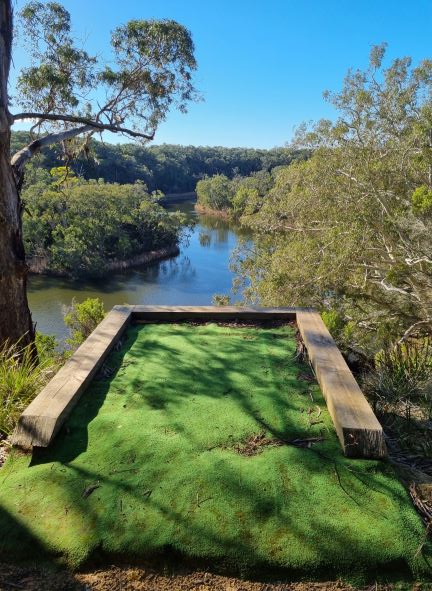

Day 5: Moleside Camp to Patterson’s Camp
Book says: 32.8km
Map says: 30.5km
Garmin says: 33.1km
Day 6: Patterson’s Camp to Nelson
Book says: 20.9km
Map says: 19.8km
Garmin says: 21.6km
I absolutely loved this section and would go back and do it again. So why cover it in only two days? Because when I was suffering in the forest, I decided I wanted to get this foresty, leechy leg over with and get to the coast and thus planned to do a double section, skipping Battersby Camp. By the time I realised how lovely it was along the river, I’d already become rather attached to the idea of two nights in Nelson so I stuck with the plan. It also probably helped that the sun came out. And I met some day hikers, the first people I had spoken to in nearly five days.
You can also canoe along the Glenelg River and the campsites are set up accordingly. I’ve put that on my bucket list.
Part of the trail actually crosses the border into South Australia so for a while you find yourself walking interstate. It’s a little bit weird.

The sign at Battersby Camp actually had information about leeches. Really? You couldn’t have told me this several camps back?? When I stopped here for lunch I did enjoy the company of a cheeky Superb Fairy Wren who wanted to share my wrap.

Intermission: ‘Rest’ Day in Nelson


I stayed at the Kywong Caravan Park in Nelson and I would heartily recommend it to anyone but especially as a break point in a long hike. There are both powered and unpowered sites but also cabins. There is a toilet/shower block that runs on solar hot water so the hot water never runs out and a laundry with both washing machines and dryers. (You can get coins from the office. It cost me $5 to wash and dry all my clothes.) There’s a camp kitchen with stove, barbeques, microwave, kettle, toaster, fridge, sinks, a table and chairs and a tv. It was lovely to sit inside a building to eat my meals. I was able to wash out all my ziplock meal bags and repackage the next week’s food. (I dropped off a resupply box on my way to Portland and the office was more than happy to look after it.)
On my so-called rest day, I decided to take a walk to Livingston’s Island which has a very enjoyable nature walk. Just a little less enjoyable in the pouring rain. (It wasn’t raining when I left. I’m not that stupid or masochistic.) The walk came to 14.6km, perhaps an odd choice on a day I should be resting but I didn’t want my legs to forget why we were there.


The service station serves very good coffee and even better crunchy hot chips. The pub serves good pub grub and has an excellent wine list. I may be speaking from experience.
Third Movement: The Beach


Day 8: Nelson to Monibeong Camp
Book says: 22.6km
Map says: 21.0km
Garmin says: 25.0km
Day 9: Monibeong Camp to Swan Lake Camp
Book says: 17.0km
Map says: 16.8km
Garmin says: 17.2km
Day 10: Swan Lake Camp to Tarragal Camp
Garmin says: 24.4km
Day 11: Tarragal Camp to Springs Camp
Garmin says: 32.7km
The third part of the journey travels along the beach of Discovery Bay. Beach walking can be tough but I did find the sand here easier to manage than on the Great Ocean Walk. Not as soft nor as thick. However…
It is recommended that you walk the GSWW in an anti-clockwise direction. This allows you to finish with the spectacular capes section and also means you have the wind at your back on the beach walks. If you walk in the warmer months. In summer, the winds blow from the north-west and this theory applies. If, however, you are ridiculous like a blogger we all know and decide to walk in winter, the winds blow from the south-east. Straight into your face. Add in the occasional burst of horizontal rain and, well, let’s just say that I was happy to walk the longer 7.5km inland route to Monibeong Camp rather than spend another 5.5km on the beach. It was a nicer walk in any case.


There was lots to look at on the first two legs – weird rock formations, interesting shells and flotsam and jetsam scattered along the beach.


There were also lots of seabirds including the threatened Pied Oyster Catcher and Hooded Plover. It was fun to “peep peep” back at the oyster catchers and reassure the scurrying little plovers that you weren’t out to get them. I understand their trepidation. There were several fox tracks in the sand along the beach.


Now, you may have noticed that I haven’t inserted the book and map distances on Days 10 and 11. This is because from Swan Lake Camp you have two choices. You can walk the approximate 22km inland over Mt Richmond to Tarragal Camp and then continue on to Springs Camp the next day (13km) or you can walk along the beach straight to Springs Camp (23km) and thus skip a day’s walking.
I wanted to do both.
So I walked along the beach but instead of continuing to Springs Camp, I turned off and walked to Tarragal Camp. The next day, I got up early, hiked to the top of Mt Richmond, walked back to camp, packed up and continued on to Springs Camp.

My advice, however, would be not to bother with the beach section. Take the inland route over Mt Richmond and stay at Tarragal. It’s worth the extra day. I found this last beach section long and tedious with not much to see. Tarragal and the Mt Richmond route, on the other hand, was Koala Central.


Just bring your ear plugs for overnight if you don’t want to be woken by grunting, growling koalas complaining that you’ve set up your tent in the path of their favourite tree. Although, I was glad to hear them when I detected a juvenile male trying to sound like his elders and instead sounded like someone having an asthma attack. I couldn’t stop laughing. (I wish I had a recording but I turn my phone off at night and I couldn’t be bothered turning it back on.)
If you don’t know what koalas sound like, here’s an example. It’s a good idea to know what this sound is so as not to be terrified you are about to be invaded by a herd of wild pigs in the middle of the night.
You’ll also pass the Bridgewater Lakes and Tarragal Caves which are well worth a visit.


Fourth Movement: Capes and Bays


Day 12: Springs Camp to Mallee Camp
Book says: 32.4km
Map says: 32.0km
Garmin says: 33.5km
Day 13: Mallee Camp to Portland Visitor Centre
Book says: 22.2km
Map says: 22.0km
Garmin says: 24.7km
This was my favourite leg. Absolutely stunning scenery, interesting things to see and the occasional adrenaline rush when the path veered just a little too close to the edge of the cliff. (These sections always seemed to come near the end of a long day when I was tired and more likely to stumble. I did a lot of very slow, very purposeful walking with my eyes glued to my feet on the path at times.)


There were so many sights on this leg that I’d like to go back with more time and see them again. A petrified forest (actually limestone tubes eroded by water), freshwater springs on ocean rocks, blowholes, shipwrecks, a seal colony and a walk along some of the highest coastal cliffs in Victoria.


There was also coffee with fresh milk in it. And a scone with jam and cream. It’s the little things. Thank you Cape Bridgewater Café.


If you stay at Trewalla Camp, you should also arrive at Cape Nelson Lighthouse in time for afternoon tea in the café the next day. Since I decided to continue on to Mallee Camp instead, I’d have needed them to be offering Sunset Tea to partake of their delights. (Because I am ridiculous. We’ve already established this fact.)

It was at Mallee Camp that I met my first fellow GSWW hiker in camp. It only took 12 days. He was only starting out, going in the opposite direction. (Because he is not ridiculous.) Mallee Camp is the only campsite with tent platforms/sandpits as it is set in an area of indigenous middens and setting up your tent in the designated areas helps protect the fragile environment.

Even on the last day there was still so much to see – an Enchanted Forest, hidden bays, a gannet colony (the only one on the Australian mainland) and a walk beneath enormous wind turbines for an up close appreciation of renewable energy production.


The walk into Portland does feel a bit interminable as you wait and wait for a glimpse of the pier but it eventually arrived and I was relieved to spot my car still where I left it.
Then it was only for me to drive the 3.5 hours home fuelled on triple shot espresso and Squirms.
And my GSWW adventure was thus over. It felt simultaneously like I had been away forever and hardly at all.

What I Learned
- Distances can be deceiving. On my second last day, I took a photo across the ocean and realised to my horror that the tiny speck on the end of the cape in the distance was the lighthouse past which I had to walk that day to get to camp. It looked about three days away. It wasn’t. I got there before dark. I’m still not sure how.

- I am not good at lighting fires. My former Girl Guide leaders would be horrified.
- I don’t much like being alone after dark. I came home thinking I would need to revamp my Great North Walk plans to stay in more established accommodation rather than camping alone in the campsites. About three days later I decided “Meh. It will be fine.” Because…
- Much like childbirth, marathons or any other activity that has you thinking at the time that you will never do this to yourself again, bad days or moments on a long hike tend to fade in the memory leaving only the excitement and enjoyment of being out in nature.
I wish to acknowledge the Gunditjmara people on whose land I journeyed and pay respect to their Elders past, present and emerging.

I love reading your experiences and I will love hearing about them in person, when we next catch up… But as always, I love the fact you can do these amazing things and I can just be there to support you in them…
LikeLiked by 1 person
And I love having your support. 😊
LikeLike
I also love hiking.. and I enjoy reading this so much. thank you for sharing
LikeLiked by 1 person
Thank you for reading! I’m glad you enjoyed it. 🙂
LikeLike
WHINGE !!! – I can’t make the ‘Like’ button work, Mosy !!
Great post – so well planned and carried out. Just like the hike, really ! 🙂
LikeLiked by 1 person
Oh. I don’t know why. Try refreshing the page and try again. I have been ducking back in to try and fix the distance tables so maybe you got caught in an update?
It just took me a while to try and distil everything in my head before I could commit it to paper…er…screen. Thanks, M-R!
LikeLiked by 1 person
What a stunner! It looks almost more beautiful than the Great Ocean Walk, but maybe that is to do with the variety. The GSWW is now firmly on my radar. Thanks for the heads up. Mel
LikeLiked by 1 person
It’s like an extended and enriched version of the GOW. I think you’d really enjoy it, Mel.
LikeLiked by 1 person
Definitely something for the list. Maybe we should have a chat offline about doing some walks together? I can’t find any other mad buggers to come with me either! 🙂
LikeLiked by 1 person
I was thinking the same thing! 😁 Email me at mosyet42@gmail.com (my public WP email) and I’ll email you back with my personal email address. Let’s chat!
LikeLiked by 1 person
Looks like such a varied walk! I had never heard of it to be honest. Thanks for enlightening me!
LikeLiked by 1 person
I’m glad I could introduce it to you. I think it’s a bit of a hidden gem.
LikeLiked by 1 person
Well, that’s me worn out before I even start the day, Heather. And pretty sure that I don’t want to do the forest part. Got to admire your guts and determination, and those kangaroos being windmills made me grin.
LikeLiked by 1 person
Sorry to wear you out but I’m sure you’d enjoy the Capes and Bays section. That kangaroo photo is one of my favourites. 😄
LikeLike
🤗💗
LikeLiked by 1 person
The captions under the photo are presented in a vertical format that is nearly impossible to read in this post. Maybe the style isn’t phone compatible?
Nevertheless a detailed account and I think you are courageous camping out solo and with your phone off.
The area looks healthy no sign of fire. And love the roo heads poking up from the bushes.
LikeLiked by 1 person
I’m sorry. The photo captions look okay to me. Perhaps you mean the distance tables under the photos at the start of each section? They are a mess in the website version on the phone (they work in the app). More trouble than their worth. I may go in and change them to a standard list.
LikeLike
Perhaps they are the distance tables. It was very hard to read them. They were under the photo so I assumed they were some kind of caption.
LikeLiked by 1 person
I have (after much cursing I must admit) found something of an imperfect work around.
There was some evidence of past fire near Fitzroy River. There was a very large fire through there a number of years ago.
LikeLiked by 1 person
What an adventure and so gutsy to do it solo! Thoroughly enjoyed your description and photos although the leeches you and we could have done without! Did you choose to hike solo or was it just hard finding the right companion? A dear friend and I hiked The Bruce Trail in Canada and worked hard to coordinate various legs of it since we live 3 hours apart. We did it over 4 years and while that pales by comparison to your feat we did feel proud of ourselves by the end. Wear your accomplishment proudly – wow! is all I can add.
LikeLiked by 1 person
Just looked up the Bruce Trail and that is an amazing achievement! Such a commitment to complete it together.
I hike solo mostly by choice. I just find it simpler to hike when and how I want. Although, I do have some shorter hikes planned with my brother. We hike in a similar way so it seems to work well but it is hard coordinating availability so you have my absolute admiration for managing it for 900km!
LikeLike
Let me bow down before you Master of Everything! Oh my goodness Heather I’m so impressed you did that alone. If I had heard those grunting koalas I may have had a cardiac event. And what about those leeches? Our Canadian leeches live in water. In Australia are they swinging from the trees?
So many beautiful photos but the one of the kangaroos and the windmills needs to be entered in a photography contest. Remarkable.
LikeLiked by 1 person
I met a couple in the caravan park who told me about a place in Queensland where they do literally rain from the trees. No thanks! I think this one crept off a log I carried onto my jumper and then up onto my neck. But then the next day I did pick them off my beanie and pants so I guess they do hitch.
One koala came right up to my tent. He was annoyed I was camped next to his favourite tree. Gave me a grumble on his way back down about an hour or so later.
That photo was such a fluke but I love it! 😁
LikeLiked by 1 person
Wow! You are and remain my hero! what an amazing trip. Thank you so much for sharing the photos and description of your experience with us. I can’t imagine not turning back after the leeches, but you certainly has some wonderful experiences after that. The photo over the water, with the arrow pointing to the lighthouse is scary. I’m glad you did it. I’m proud of you and I am very happy you made it safely.
LikeLiked by 1 person
I’ll confess that for a fleeting moment on that Night of the Leech, I considered going home but I have a very stubborn streak so I had to push on and obviously I’m glad I did.
When I saw that lighthouse in the distance I actually got out the map because I was convinced it must be a different lighthouse but no, that was the one. It still astounds me that I walked that far but it was only a day’s walk. So weird.
Thank you for such kind words, Dan.
LikeLiked by 1 person
Heather! you did this all on your own and in one go. I am astounded and so impressed by your tenacity and perseverance. That first meeting with a leech would have done me in and that would have been the end of that! Congratulations.
LikeLiked by 1 person
Thanks so much, Carol. As I said to Dan, I did consider, just for a second, giving up and going home after the leech incident but I’m not really one for giving up and part of taking up this new activity is to push myself outside my comfort zone. I guess I definitely got to do that on this trip!
LikeLiked by 1 person
The older I get the more appealing my comfort zone is. 🙂
LikeLiked by 1 person
I have a tendency to get bored. 😁
LikeLike
Pingback: Jo’s Monday walk : Praia da Luz to Burgau | Still Restlessjo
Oh my, Heather, I’d have a hard time keeping up with you for one day, let alone 14. You are really a strong and determined hiker! I would have screamed and gone home with the whole leech situation (just like June bugs, leeches are a childhood freak-out moment that has stuck with me into old age). The scenery on your walk is gorgeous and I love the river and the ocean – biking along the water is one of my favorite things! I admire you for taking on such an adventure and going it alone. I don’t think I could do what you did.
LikeLiked by 1 person
Thanks, Mary. I’m never really sure I can do it myself until I do it. 😄 I find the water so fascinating and uplifting. Love it.
LikeLiked by 1 person
What a wonderful walk and love your sense of humour all the way. Well done on finishing the Great South West Walk all in one hit. Not surprised at all since you are very seasoned and well, nothing stops you at all! No obstacle can get in the way and you went above and beyond wanting to do it all. In terms of photos, I’d say like you, Capes and Bays is my favourite. Absolutely stunning views and lovely winter weather too – though it would have probably been too cold for me even with walking anti-clockwise with the wind blowing at my back lol.
Great reflections at the end. Once you get going, you probably don’t want to stop until you reach the end 😄
LikeLiked by 1 person
Thanks, Mabel. Yes, well, when your car is waiting for you in Portland there’s not much choice but to keep going. 😁
LikeLiked by 1 person